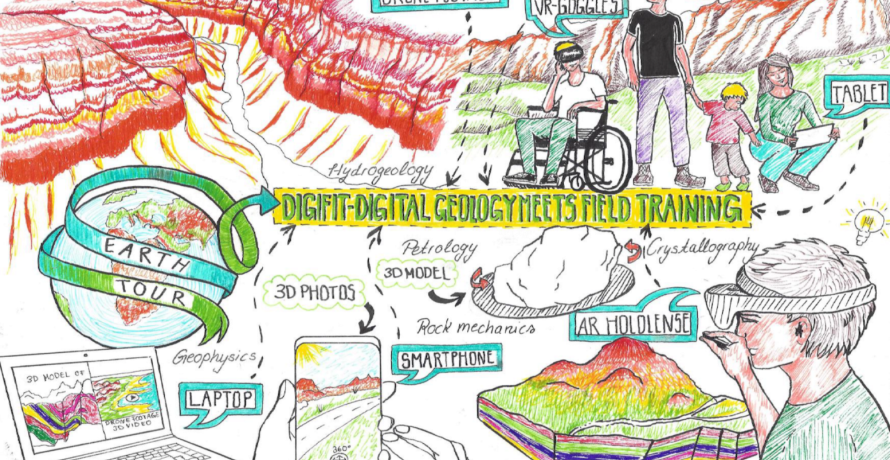
Natural Sciences

alt text
Read More

The AAA data model

How much forest area is there in a district? How well is a municipality provided with daycare centers? Where might there be gaps in basic medical care? These are all questions that require spatial data to answer. Such geodata is available throughout Germany in the form of basic geodata. This data is organized and made available to users in the AFIS-ALKIS-ATKIS data model.

alt text
Read More

CDEC: Climate Data Entrepreneurial Club

In future, the CDEC website will provide teaching materials and learning modules on the topics of digital, AI and (geo)data skills. The content focuses on the processing of climate data and the development of solutions to combat climate change.

alt text
Read More

Columbus Eye & LEIA

The Columbuseye / LEIA website contains various teaching materials and further background information on the topics of remote sensing, the Moon and the Earth-Moon system, which have been prepared interactively for students and teachers.

alt text
Read More

Remote Sensing in Schools

The "Remote Sensing in Schools" (FIS) project is an educational initiative that focuses on the use of remote sensing technologies in schools to impart knowledge and skills to students in this field.

alt text
Read More

Earth observation: EO-College

EO College is an educational platform specializing in Earth Observation (EO). It offers a comprehensive range of resources and courses designed to educate students, professionals, and enthusiasts about the world of Earth observation.

alt text
Read More

ESERO Germany

The ESERO Germany is a joint project of ESA and the German Aerospace Centre (DLR). The Ruhr-University Bochum and a committed consortium of ten institutions from North Rhine-Westphalia were awarded the contract to set up the ESERO office. The ESERO project develops teaching materials, offers training for teachers on space topics such as Earth observation, navigation, communication and space exploration and participates in national school competitions and projects organised by ESA and DLR.

alt text
Read More

Digifit - Digital geology meets inclusive field training

As part of a digitally guided geological mapping as a 360° tour, virtual reality experiences with high-resolution 3D models are included alongside images of excursion destinations and rock samples.

alt text
Read More

Digital Anatomy

An image collection of more than 700 histological and pathological samples is made available with content allocation to the various organ systems of the human body.